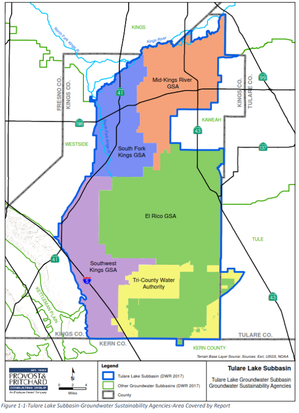
Groundwater in the Tulare Lake Subbasin: Annual Report Update
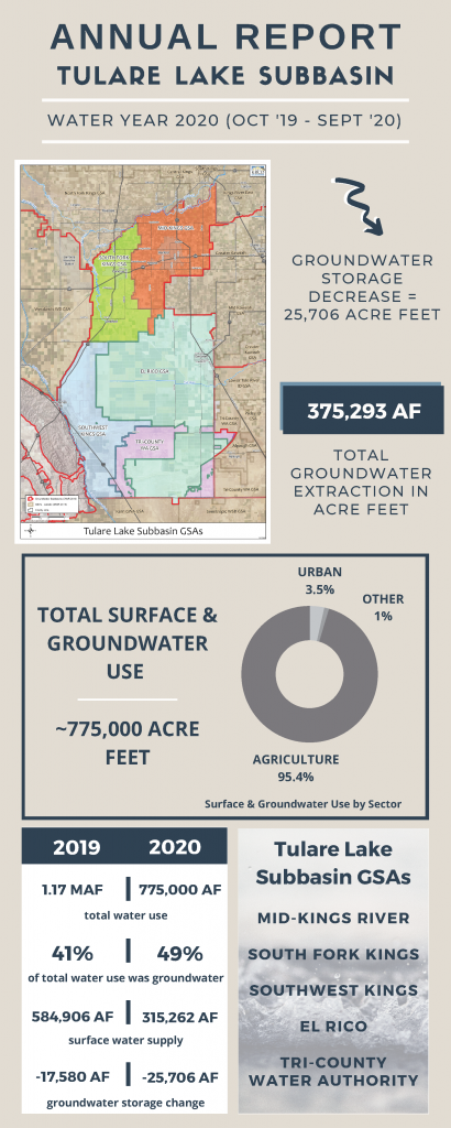
The South Fork Kings GSA (SFKGSA), together with the four other GSAs in the Tulare Lake Subbasin, submitted the second Annual Report to the CA Department of Water Resources (DWR) by the April 1, 2021 deadline. Dryer conditions in water year 2020 (Sept 2019 – Oct 2020) strained groundwater supplies across the Tulare Lake Subbasin, evidence that cooperation among groundwater users and strategic surface supply management will be critical to achieving sustainability by 2040.
The Annual Report includes an overview of groundwater conditions in the region including groundwater extraction, surface water supply available for groundwater recharge, total water use, change in groundwater storage, and a description of progress made toward implementing the Groundwater Sustainability Plan (GSP) since the last Annual Report.
The Sustainable Groundwater Management Act (SGMA) requires Groundwater Sustainability Agencies (GSAs) to submit annual reports to the Department of Water Resources (DWR) on April 1 of every year.
The Tulare Lake Subbasin extracted 100,000 acre-feet (AF) less than the prior water year, but due to dryer conditions during Water Year 2020, the Subbasin also saw an overall decrease of 25,706 AF in groundwater storage as observed in this year’s Annual Report. As we review the Annual Report and consider its implications as we enter another dry water year, SFKGSA will continue to implement innovative projects that will lead to a sustainable, resilient, and steadfast supply of groundwater for the region.
Here are a few SFKGSA highlights from the Tulare Lake Subbasin’s 2020 Annual Report:
SFKGSA participated in discussions with the San Joaquin Valley Blueprint to increase water supplies to the area.
Based on several wells being destroyed or inaccessible, SFKGSA worked with local landowners to modify the groundwater monitoring network. Access agreements were obtained for the modified network to ensure its long-term availability.
SFKGSA applied for and was awarded a grant from the California Resilience Challenge to implement an Aquifer Storage and Recovery (ASR) Pilot Test. Click HERE to learn more about this supply enhancement program and the progress made thus far.
SFKGSA participated in coordination meetings between the Kaweah and Tulare Lake Subbasins. The purpose of the meetings was to identify issues, discuss boundary conditions, and share data across the region. These meetings are expected to continue to help provide common solutions to regional issues. SFKGSA will continue to engage with neighboring subbasins and GSAs to promote inter-basin coordination.
Click HERE to read full Annual Report.
To receive updates on these projects and more, groundwater conditions, and other ways to get involved with the work SFKGSA is doing, sign up for our E-Updates and visit our website at southforkkings.org.