Consultants update Board on the groundwater model, a Groundwater Sustainability Plan foundation
At the July 19th Board Workshop, South Fork Kings Groundwater Sustainability Agency (GSA) technical consultants Geosyntec provided a Groundwater Sustainability Plan (GSP) update as well as an overview of the components and capabilities of the groundwater model, a critical GSP component for setting sustainability objectives and identifying potential projects for the GSA. The groundwater model is in preliminary draft form, and the information presented has not been accepted or approved by any organizations.
The Groundwater Sustainability Plan is a detailed roadmap for how the Tulare Lake Subbasin will reach long-term sustainability. The law requires the GSA to submit a GSP to the State by January 2020; the South Fork Kings GSA has agreed to coordinate with the five other GSA’s within the Tulare Lake Subbasin to submit a single GSP. The South Fork Kings GSA’s role within the larger Subbasin effort is to provide specific input for each component of the GSP that includes GSA-specific concerns, projects, and management actions (click here to view the CA Department of Water Resources GSP Outline).
A fundamental component of the GSP is the Basin Setting chapter. The chapter includes foundational information regarding the groundwater conditions of the Tulare Lake Subbasin, including the groundwater model, and works to provide context and direction for setting measurable sustainability objectives and identifying solutions to reach those objectives. With data input, the groundwater model uses accurate representation of past conditions to create confidence in future predictions. It utilizes data from the river/canal system, crop demand, subsidence, and well monitoring to assess groundwater conditions such as inter-basin groundwater flows and groundwater pumping amounts.
The model can use data to simulate groundwater contour maps like the one pictured below (click to enlarge) of the Tulare Lake Subbasin. Groundwater contour maps show groundwater elevation (feet above mean sea level) along contour lines to illustrate the direction that groundwater flows within the Subbasin. Water flows perpendicular to contour lines from higher elevations to lower elevations.
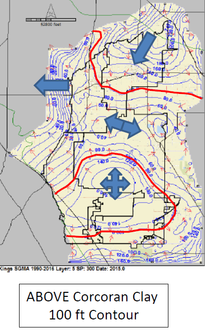
The map above was created using the preliminary groundwater model, and is in preliminary draft form and subject to change pending data improvements and model recalibration.
The map was created using data from the period 1990-2016 and indicates groundwater elevation and flows in the Tulare Lake Subbasin above the Corcoran Clay. The blue arrows indicate the general directions that groundwater is flowing within the Subbasin. Groundwater flows generally from east to west in the northern part of the Subbasin, but the elevations indicate the Tulare Lake bottom in the southern half of the GSA is a mound that causes water to flow all directions out of the lake bed. This type of information is an important factor for calculating a groundwater overdraft amount, since groundwater may be flowing into other GSA’s but out of others, or a combination of both.
Groundwater flows and storage change are a key coordination issue in GSP development; the values calculated by the South Fork Kings GSA groundwater model need to be consistent with technical work in adjacent GSA’s to ensure appropriate groundwater overdraft amount is assigned and accounted for across the Subbasin.
The model is currently in its first iteration, and the technical consultants plan to recalibrate it over the coming months to include improved data and information for sharper accuracy in modeling predictions. The model is just one part of a larger picture required for the GSP, but it is an important aspect of plan development for the South Fork Kings GSA as it helps shape the programs and projects that will be implemented to reach sustainability by 2040.