Skip to content Skip to footer

Groundwater Sustainability Plan

Adaptive management is essential on the years-long road to sustainability

Reaching groundwater sustainability in the Tulare Lake Subbasin, and in subbasins across the State, will require periodic management adjustments. Not only will the formality of updating the Groundwater Sustainability Plan (GSP) every five years for mandatory resubmittal to CA Department of Water Resources call for adjustments, actually achieving sustainability will require learned modifications as time lends improved data and as the effects of implemented strategies are observed.

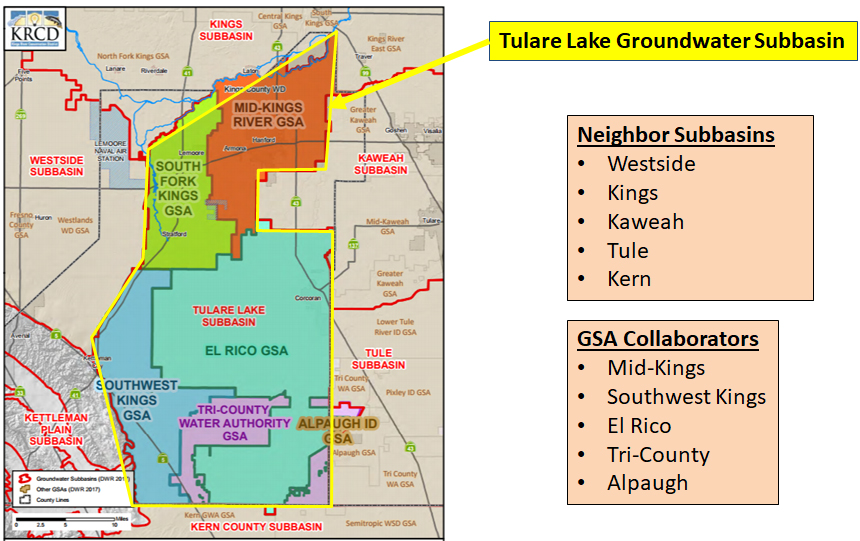
The Tulare Lake Subbasin will soon have an estimation for the amount of groundwater overdraft in the subbasin. Each of the six GSAs within the subbasin will be responsible for a portion of the total overdraft amount. SGMA stipulates that all subbasins reach sustainability by the year 2040, correcting the groundwater overdraft and maintaining a sustainable level of groundwater use.

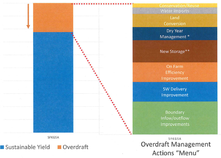
Efforts to correct groundwater overdraft will include a number of varying projects and actions that will either increase the supply or decrease the demand for water. The South Fork Kings GSA is considering a “menu” of these overdraft management items, broken into several categories presented by the GSA’s technical consultant Geosyntec.

(click to enlarge)

SW = surface water

The management action “menu” in the above image represents possible solutions to correct groundwater overdraft. Overdraft is represented by the orange bar on the left of the image. The menu items: conservation/reuse, water imports, land conversion, dry year management, new storage, on farm efficiency improvement, surface water delivery improvement, are represented by varying colored bars. Acknowledging resource scarcity, the variance in menu item size is proportional to the number of actions pursued within the menu item by the GSA. For example, this menu shows boundary inflow/outflow improvements holding the largest proportion of the management action menu, meaning it will consume a larger portion of the GSA’s solutions than all other listed items.

As the South Fork Kings GSA periodically monitors progress toward its 2040 sustainability goal, adjustments may be made to the proportion assigned to the menu items. For example, the figure below illustrates a scenario in which the GSA decides in 2030 to increase surface water delivery and decrease boundary inflow/outflow improvements, among other adjustments. The illustration shows modifications to the menu again in 2040.

(click to enlarge)

SW = surface water

The South Fork Kings GSA is working to refine its understanding of the current problem so it can best allocate resources to the most efficient and effective proportion of menu item solutions. But the implementation of groundwater sustainability will inevitably be an iterative process requiring adjustments over time. These adjustments may be made for a variety of reasons, such as an increase in data to inform trends, financial/economic factors, and/or fluctuations in water availability.

The Tulare Lake Subbasin will submit one Groundwater Sustainability Plan to CA DWR in January 2020, but GSP implementation in the South Fork Kings GSA service area is up to the discretion of the GSA; varying projects and management actions to benefit the service area will be considered and approved by the South Fork Kings GSA Board.

Project and management action concepts discussed at Board workshop

At the October 18th Board workshop, the South Fork Kings GSA’s technical consultant Geosyntec introduced potential management concepts for mitigating groundwater overdraft in the South Fork Kings area. SGMA requires subbasins become sustainable by the year 2040; the means to achieve that mandate are the projects and management actions that will be included in the Tulare Lake Subbasin Groundwater Sustainability Plan (GSP).

A reduction in groundwater use, an increase in groundwater recharge, and the implementation of programs and management actions to increase water use efficiency are broad strategies for establishing a trajectory toward sustainability.

Project concepts to reduce groundwater use include the acquisition of additional surface water, or crop conversion to less water demanding crops. Both solutions carry the potential to offset groundwater demand. Increasing the amount of groundwater recharged in the South Fork Kings area to stabilize water levels can be accomplished a number of ways, either through the construction of additional dedicated recharge basins or through “incidental” means by way of flood irrigation and canal seepage.

To provide flexibility, the GSA seeks to provide a menu of programs and management actions for landowners in its service area. Program concepts may include water markets and groundwater crediting systems, allowing water trading among growers within the GSA and consequently incentivizing water use efficiency.

The management concepts discussed are in the early stages of consideration. The South Fork Kings GSA is working to factor local conditions, economic constraints, and stakeholder input as it identifies a project portfolio that achieves State-mandated sustainability.

Groundwater Sustainability Plan schedule update

The South Fork Kings GSA is coordinating with the other five GSAs of the Tulare Lake Subbasin to complete a Groundwater Sustainability Plan (GSP) by the state-mandated deadline of January 31, 2020. Although the subbasin will submit a single GSP that outlines the path toward sustainability, the South Fork Kings GSA’s contribution will ensure local issues, projects and management actions are included.

The GSP schedule is pictured below (click to enlarge). Drafted chapters, Plan Area and Basin Setting, provide a foundational framework to establish the Sustainable Management Criteria. This chapter is anticipated for completion in November 2018.

GSP Schedule

Sustainable Management Criteria are the goals that measure success of groundwater level stabilization. The criteria includes:

          Measurable objective: average maintained groundwater level over the long-term that must be met by 2040.

          Minimum threshold: the lowest possible groundwater level allowed in the worst case scenario. Level cannot cause an undesirable result (ie. significant and unreasonable degraded water quality) and thus cannot be arbitrary.

These metrics are included in the GSP and must be approved by the CA Department of Water Resources.

Consultants update Board on the groundwater model, a Groundwater Sustainability Plan foundation

At the July 19th Board Workshop, South Fork Kings Groundwater Sustainability Agency (GSA) technical consultants Geosyntec provided a Groundwater Sustainability Plan (GSP) update as well as an overview of the components and capabilities of the groundwater model, a critical GSP component for setting sustainability objectives and identifying potential projects for the GSA. The groundwater model is in preliminary draft form, and the information presented has not been accepted or approved by any organizations.

The Groundwater Sustainability Plan is a detailed roadmap for how the Tulare Lake Subbasin will reach long-term sustainability. The law requires the GSA to submit a GSP to the State by January 2020; the South Fork Kings GSA has agreed to coordinate with the five other GSA’s within the Tulare Lake Subbasin to submit a single GSP. The South Fork Kings GSA’s role within the larger Subbasin effort is to provide specific input for each component of the GSP that includes GSA-specific concerns, projects, and management actions (click here to view the CA Department of Water Resources GSP Outline).

A fundamental component of the GSP is the Basin Setting chapter. The chapter includes foundational information regarding the groundwater conditions of the Tulare Lake Subbasin, including the groundwater model, and works to provide context and direction for setting measurable sustainability objectives and identifying solutions to reach those objectives. With data input, the groundwater model uses accurate representation of past conditions to create confidence in future predictions. It utilizes data from the river/canal system, crop demand, subsidence, and well monitoring to assess groundwater conditions such as inter-basin groundwater flows and groundwater pumping amounts.

The model can use data to simulate groundwater contour maps like the one pictured below (click to enlarge) of the Tulare Lake Subbasin. Groundwater contour maps show groundwater elevation (feet above mean sea level) along contour lines to illustrate the direction that groundwater flows within the Subbasin. Water flows perpendicular to contour lines from higher elevations to lower elevations.

The map above was created using the preliminary groundwater model, and is in preliminary draft form and subject to change pending data improvements and model recalibration.

The map was created using data from the period 1990-2016 and indicates groundwater elevation and flows in the Tulare Lake Subbasin above the Corcoran Clay. The blue arrows indicate the general directions that groundwater is flowing within the Subbasin. Groundwater flows generally from east to west in the northern part of the Subbasin, but the elevations indicate the Tulare Lake bottom in the southern half of the GSA is a mound that causes water to flow all directions out of the lake bed.  This type of information is an important factor for calculating a groundwater overdraft amount, since groundwater may be flowing into other GSA’s but out of others, or a combination of both.

Groundwater flows and storage change are a key coordination issue in GSP development; the values calculated by the South Fork Kings GSA groundwater model need to be consistent with technical work in adjacent GSA’s to ensure appropriate groundwater overdraft amount is assigned and accounted for across the Subbasin.

The model is currently in its first iteration, and the technical consultants plan to recalibrate it over the coming months to include improved data and information for sharper accuracy in modeling predictions. The model is just one part of a larger picture required for the GSP, but it is an important aspect of plan development for the South Fork Kings GSA as it helps shape the programs and projects that will be implemented to reach sustainability by 2040.

The Model, the Data and Groundwater Sustainability

At the February 1 Board meeting, South Fork Kings Groundwater Sustainability Agency (GSA) technical consultant, Bob Anderson of Geosyntec Consultants, covered what a model can and cannot do and the importance of data and how they will be used in determining groundwater sustainability in the Tulare Lake Subbasin.

To guide regional activities necessary to implementing the Sustainable Groundwater Management Act of 2014 (SGMA), a Groundwater Sustainability Plan (GSP) will be prepared to cover the entire Tulare Lake Subbasin (see diagram below). The South Fork Kings GSA is one of six GSAs within the subbasin that must coordinate their planning to complete a shared GSP, but coordination is not limited to the six GSAs.

The Tulare Lake Subbasin is delineated by a political rather than scientific boundary. The geological or physical boundary of the principal aquifer, the San Joaquin Valley Basin, is bound on the east by the Sierra Nevada, to the west by the Coastal Range and north and south by Sacramento and the Tehachapi Mountains. The Tulare Lake Subbasin is 1 of 16 subbasins within very large (9-million acre/14,000 sq/mi) San Joaquin Valley Basin.

In order to understand and address water flow between political boundaries SGMA also requires that GSAs in each subbasin coordinate with GSAs in neighboring subbasins. The visual below shows the South Fork Kings GSA, the five other GSAs in the Tulare Lake Subbasin and their neighboring subbasins.

The core element for the GSP is its water budget, which describes the amount of water coming into a subbasin versus the amount going out. A good comparison for understanding how a water budget works is to think of it as a bank account. SGMA requires that a subbasin identify impacts of over-pumping and then take corrective actions that will result in long-term sustainability. It is up to the South Fork Kings GSA Board to define what “sustainable” means within its jurisdiction and in the entire Tulare Lake Subbasin through coordination with neighboring GSAs.

Water Budget Diagram

A computer model is a tool that breaks down an area into thousands of individual water balance cubes that when combined can make very complex groundwater flow and water balance calculations.

The computer model for the Tulare Lake Subbasin will assess the six undesirable results as defined by SGMA. Defining these six undesirable results for the South Fork Kings will be the roadmap to sustainability for the groundwater subbasin. The diagram below illustrates how a model computes one undesirable result, the chronic lowering of groundwater levels.

Models need data. Data is the best indication of what is going on. Where data does not exist, assumptions must be made and therefore the more data there is the better the analysis will be. Some data is already available through sources like the Department of Water Resources (DWR) that has collected depth to groundwater data for years.

Other important data needed include surface water diversions and cropping patterns. In the absence of measured groundwater well pumping rates, the Tulare Lake Subbasin model will back its way into a groundwater pumping estimate using cropping pattern data coupled with irrigation estimates and measured surface water diversions.

Tulare Lake Subbasin Pumping = Crop Consumptive UseSurface Water Delivery

The model and data are a couple of the pieces needed to complete the GSP by the State’s deadline of January 2020. 

Board Supports Effort to Develop a Single GSP for the Tulare Lake Subbasin

At a special meeting on July 20, the South Fork Kings GSA Board of Directors approved entering into an agreement to facilitate a coordinated effort to develop and implement a single Groundwater Sustainability Plan for the Tulare Lake Subbasin. The interim agreement creates a cost-share schedule and basic decision-making structure for the selection of a consultant to prepare a grant application. It is intended to be modified or replaced by a more comprehensive and longer-term coordination agreement following grant award recommendations later this year. The signatories to the agreement are South Fork Kings GSA, Mid Kings GSA, El Rico GSA, Southwest Kings GSA, Tri-County Water Authority, and Alpaugh Irrigation District.

Other actions by the Board included the approval of a $265,250 budget for fiscal year 2018 and the selection of Geosyntec Consultants to perform technical engineering services. Budget expenses include engineering services, legal costs, Tulare Lake Subbasin coordination, and administrative services including outreach. Geosyntec will support the South Fork Kings with planning and implementing of a Proposition 218 and/or Proposition 26 elections; oversee, manage and coordinate preparation of a Groundwater Sustainability Plan; and other technical support including coordination with  adjacent groundwater sustainability agencies.

Translate »