Author: Website Admin
Project and management action concepts discussed at Board workshop
At the October 18th Board workshop, the South Fork Kings GSA’s technical consultant Geosyntec introduced potential management concepts for mitigating groundwater overdraft in the South Fork Kings area. SGMA requires subbasins become sustainable by the year 2040; the means to achieve that mandate are the projects and management actions that will be included in the Tulare Lake Subbasin Groundwater Sustainability Plan (GSP).
A reduction in groundwater use, an increase in groundwater recharge, and the implementation of programs and management actions to increase water use efficiency are broad strategies for establishing a trajectory toward sustainability.
Project concepts to reduce groundwater use include the acquisition of additional surface water, or crop conversion to less water demanding crops. Both solutions carry the potential to offset groundwater demand. Increasing the amount of groundwater recharged in the South Fork Kings area to stabilize water levels can be accomplished a number of ways, either through the construction of additional dedicated recharge basins or through “incidental” means by way of flood irrigation and canal seepage.
To provide flexibility, the GSA seeks to provide a menu of programs and management actions for landowners in its service area. Program concepts may include water markets and groundwater crediting systems, allowing water trading among growers within the GSA and consequently incentivizing water use efficiency.
The management concepts discussed are in the early stages of consideration. The South Fork Kings GSA is working to factor local conditions, economic constraints, and stakeholder input as it identifies a project portfolio that achieves State-mandated sustainability.
Groundwater Sustainability Plan schedule update
The South Fork Kings GSA is coordinating with the other five GSAs of the Tulare Lake Subbasin to complete a Groundwater Sustainability Plan (GSP) by the state-mandated deadline of January 31, 2020. Although the subbasin will submit a single GSP that outlines the path toward sustainability, the South Fork Kings GSA’s contribution will ensure local issues, projects and management actions are included.
The GSP schedule is pictured below (click to enlarge). Drafted chapters, Plan Area and Basin Setting, provide a foundational framework to establish the Sustainable Management Criteria. This chapter is anticipated for completion in November 2018.
GSP Schedule

Sustainable Management Criteria are the goals that measure success of groundwater level stabilization. The criteria includes:
Measurable objective: average maintained groundwater level over the long-term that must be met by 2040.
Minimum threshold: the lowest possible groundwater level allowed in the worst case scenario. Level cannot cause an undesirable result (ie. significant and unreasonable degraded water quality) and thus cannot be arbitrary.
These metrics are included in the GSP and must be approved by the CA Department of Water Resources.
Consultants update Board on the groundwater model, a Groundwater Sustainability Plan foundation
At the July 19th Board Workshop, South Fork Kings Groundwater Sustainability Agency (GSA) technical consultants Geosyntec provided a Groundwater Sustainability Plan (GSP) update as well as an overview of the components and capabilities of the groundwater model, a critical GSP component for setting sustainability objectives and identifying potential projects for the GSA. The groundwater model is in preliminary draft form, and the information presented has not been accepted or approved by any organizations.
The Groundwater Sustainability Plan is a detailed roadmap for how the Tulare Lake Subbasin will reach long-term sustainability. The law requires the GSA to submit a GSP to the State by January 2020; the South Fork Kings GSA has agreed to coordinate with the five other GSA’s within the Tulare Lake Subbasin to submit a single GSP. The South Fork Kings GSA’s role within the larger Subbasin effort is to provide specific input for each component of the GSP that includes GSA-specific concerns, projects, and management actions (click here to view the CA Department of Water Resources GSP Outline).
A fundamental component of the GSP is the Basin Setting chapter. The chapter includes foundational information regarding the groundwater conditions of the Tulare Lake Subbasin, including the groundwater model, and works to provide context and direction for setting measurable sustainability objectives and identifying solutions to reach those objectives. With data input, the groundwater model uses accurate representation of past conditions to create confidence in future predictions. It utilizes data from the river/canal system, crop demand, subsidence, and well monitoring to assess groundwater conditions such as inter-basin groundwater flows and groundwater pumping amounts.
The model can use data to simulate groundwater contour maps like the one pictured below (click to enlarge) of the Tulare Lake Subbasin. Groundwater contour maps show groundwater elevation (feet above mean sea level) along contour lines to illustrate the direction that groundwater flows within the Subbasin. Water flows perpendicular to contour lines from higher elevations to lower elevations.
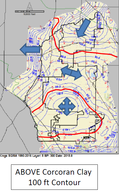
The map above was created using the preliminary groundwater model, and is in preliminary draft form and subject to change pending data improvements and model recalibration.
The map was created using data from the period 1990-2016 and indicates groundwater elevation and flows in the Tulare Lake Subbasin above the Corcoran Clay. The blue arrows indicate the general directions that groundwater is flowing within the Subbasin. Groundwater flows generally from east to west in the northern part of the Subbasin, but the elevations indicate the Tulare Lake bottom in the southern half of the GSA is a mound that causes water to flow all directions out of the lake bed. This type of information is an important factor for calculating a groundwater overdraft amount, since groundwater may be flowing into other GSA’s but out of others, or a combination of both.
Groundwater flows and storage change are a key coordination issue in GSP development; the values calculated by the South Fork Kings GSA groundwater model need to be consistent with technical work in adjacent GSA’s to ensure appropriate groundwater overdraft amount is assigned and accounted for across the Subbasin.
The model is currently in its first iteration, and the technical consultants plan to recalibrate it over the coming months to include improved data and information for sharper accuracy in modeling predictions. The model is just one part of a larger picture required for the GSP, but it is an important aspect of plan development for the South Fork Kings GSA as it helps shape the programs and projects that will be implemented to reach sustainability by 2040.
Proposition 218 Election to Fund Local Groundwater Management Passes
Landowners residing in the South Fork Kings GSA voted in favor of a $9.80 per acre assessment to cover the costs associated with implementing the State’s groundwater law, the Sustainable Groundwater Management Act (SGMA). Following the close of the Proposition 218 public hearing on June 21st, the South Fork Kings GSA Board tabulated and certified the results of the election. The assessment was favored by 74% of received votes. A majority of received votes was needed to pass the assessment; votes were weighted be acreage.
The Board approved and set a rate of $9.80/acre for the fiscal year 2018-19. Each year, the Board will set a rate not to exceed the $9.80/acre maximum for the five-year lifespan of the assessment. All landowners within the boundaries of the South Fork Kings GSA, excluding those residing in the City of Lemoore, will be assessed the rate via Kings County tax rolls beginning fiscal year 2018-19. The City of Lemoore has entered into a cost sharing agreement on behalf of all property in the City limits and has incorporated ongoing payments into their existing rate structure.
The Board is committed to keeping local jurisdiction over groundwater management under SGMA, where landowner dollars are used more efficiently and beneficially. With funding from the election, the GSA is equipped to meet the nearest deadline: completion of a Groundwater Sustainability Plan (GSP) by January 2020.
You can use the following DWR tool to determine if your property lies within the boundaries of the South Fork Kings GSA: DWR GSA Map Tool
—
Proposition 218 is a Constitutional Initiative approved by the voters of California in November 1996. It requires new or increased fees and assessments be approved by affected landowners.
An Engineer’s Report was conducted to set the $9.80/acre assessment rate. The Report calculates the equitable distribution of the benefit derived from each parcel within the agency upon which assessment will be levied. The Engineer’s Report discusses benefits of the Agency’s organization, proposed actions, and services provided by the South Fork Kings Groundwater Sustainability Agency.
Board Approves Engineer’s Report, Moves Forward with Prop 218 Assessment
At the March 15th board meeting, South Fork Kings Groundwater Sustainability Agency (GSA) board members approved the Engineer’s Report prepared by Geosyntec Consultants. The Engineer’s Report was presented by the South Fork Kings GSA technical consultant, Amer Hussain of Geosyntec Consultants. Adoption of the Report signals Board approval for a Proposition 218 Election, a Constitutional Initiative passed by CA voters in 1996 that requires all new or increased assessments be approved by affected landowners. All landowners within the boundaries of the South Fork Kings GSA will be asked to vote on the newly proposed assessment. Its purpose is to fund the local GSA’s efforts to comply with the unfunded CA state law, the Sustainable Groundwater Management Act (SGMA).
The Engineer’s Report outlines the South Fork Kings GSA’s five-year projected operating costs and expenses associated with the development and initial implementation of a Groundwater Sustainability Plan as required by SGMA, ongoing administration, technical assessments, and recovery startup costs incurred by the South Fork Kings member agencies. Click image below to enlarge.
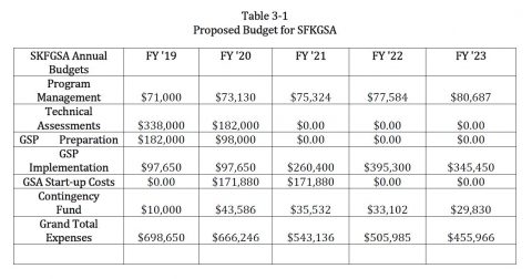
Additional components of the report include background information on the GSA, summary of GSA operations, a description of the proposed assessment, a determination of benefits derived from the assessment, and procedures to implement the assessment. Based on the model developed, the maximum annual rate proposed for assessment is $9.80 per acre for the five-year life of the proposed assessment, subject to annual review and determination by the Board. The assessment rate levied cannot exceed $9.80 without another election for voter approval. You can view the full Engineer’s Report here: Engineer’s Report.
If the South Fork Kings GSA is unable to fund its efforts to comply with SGMA, the State will intervene. The Board seeks to avoid costly State Intervention and keep SGMA implementation at the local level. To find more information regarding the assessment, visit our Prop 218 page.