Position available: General Manager
South Fork Kings GSA is conducting a series of surveys with landowners to better understand groundwater and land use. The first survey was designed to help the GSA understand landowners’ perspectives on how climate and drought impacts their groundwater supply.
Questions answered by respondents included: “On a scale of 0 (no threat) to 5 (greatly threatens), how much do you think climate change threatens your groundwater supply?” and “On a scale of 0 to 5, how would you rate the ability of your groundwater supply to recover from periods of drought?“.
The survey was conducted in June 2021, and results are now available to review on the survey webpage.
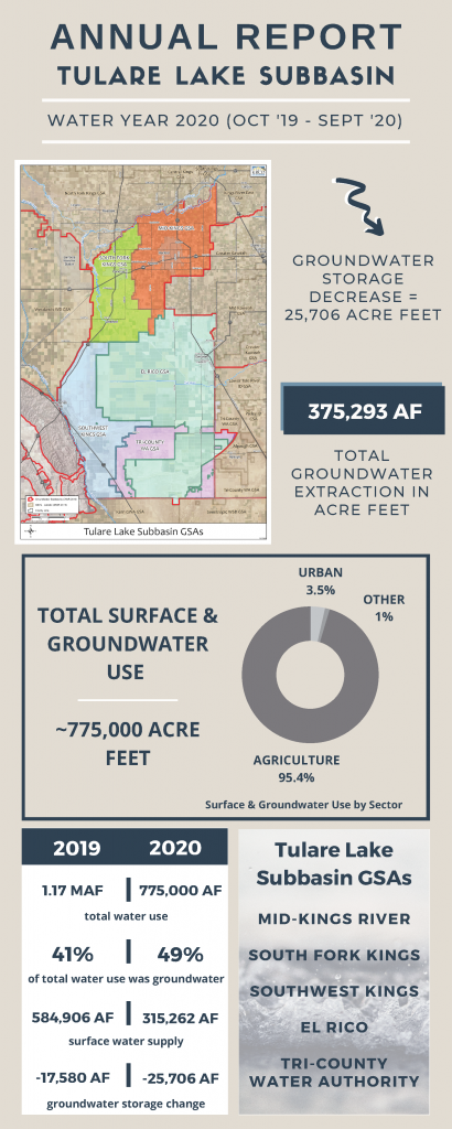
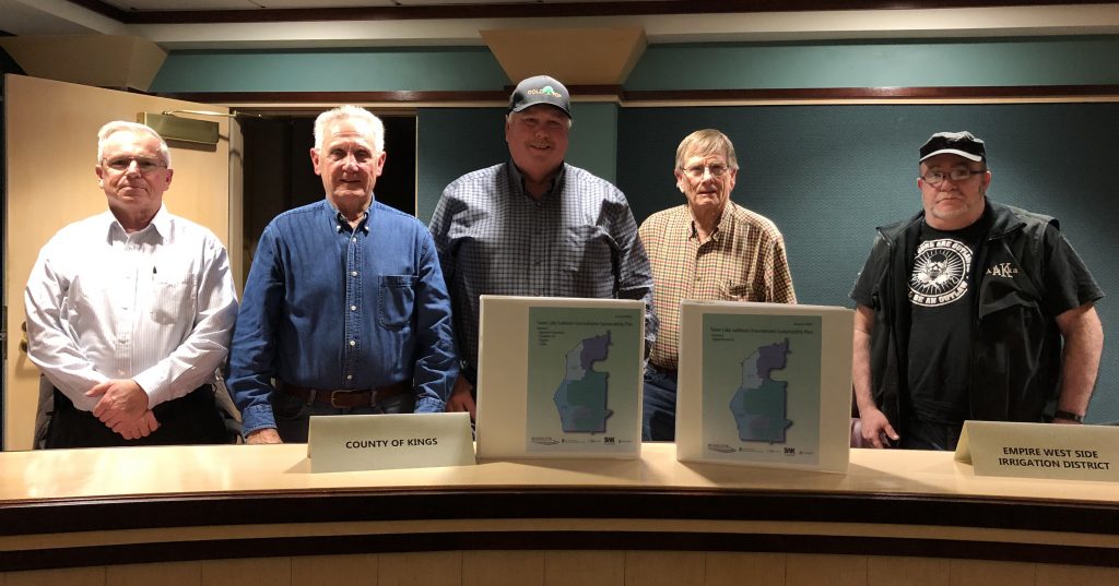
The South Fork Kings GSA (SFKGSA), together with the four other GSAs in the Tulare Lake Subbasin, submitted the second Annual Report to the CA Department of Water Resources (DWR) by the April 1, 2021 deadline. Dryer conditions in water year 2020 (Sept 2019 – Oct 2020) strained groundwater supplies across the Tulare Lake Subbasin, evidence that cooperation among groundwater users and strategic surface supply management will be critical to achieving sustainability by 2040.
The Annual Report includes an overview of groundwater conditions in the region including groundwater extraction, surface water supply available for groundwater recharge, total water use, change in groundwater storage, and a description of progress made toward implementing the Groundwater Sustainability Plan (GSP) since the last Annual Report.
The Sustainable Groundwater Management Act (SGMA) requires Groundwater Sustainability Agencies (GSAs) to submit annual reports to the Department of Water Resources (DWR) on April 1 of every year.
The Tulare Lake Subbasin extracted 100,000 acre-feet (AF) less than the prior water year, but due to dryer conditions during Water Year 2020, the Subbasin also saw an overall decrease of 25,706 AF in groundwater storage as observed in this year’s Annual Report. As we review the Annual Report and consider its implications as we enter another dry water year, SFKGSA will continue to implement innovative projects that will lead to a sustainable, resilient, and steadfast supply of groundwater for the region.
Here are a few SFKGSA highlights from the Tulare Lake Subbasin’s 2020 Annual Report:
SFKGSA participated in discussions with the San Joaquin Valley Blueprint to increase water supplies to the area.
Based on several wells being destroyed or inaccessible, SFKGSA worked with local landowners to modify the groundwater monitoring network. Access agreements were obtained for the modified network to ensure its long-term availability.
SFKGSA applied for and was awarded a grant from the California Resilience Challenge to implement an Aquifer Storage and Recovery (ASR) Pilot Test. Click HERE to learn more about this supply enhancement program and the progress made thus far.
SFKGSA participated in coordination meetings between the Kaweah and Tulare Lake Subbasins. The purpose of the meetings was to identify issues, discuss boundary conditions, and share data across the region. These meetings are expected to continue to help provide common solutions to regional issues. SFKGSA will continue to engage with neighboring subbasins and GSAs to promote inter-basin coordination.
Click HERE to read full Annual Report.
To receive updates on these projects and more, groundwater conditions, and other ways to get involved with the work SFKGSA is doing, sign up for our E-Updates and visit our website at southforkkings.org.
The South Fork Kings Groundwater Sustainability Agency (SFKGSA) along with their technical consultant, Geosyntec Consultants and Kings River Conservation District, successfully obtained a $200,000 grant to support groundwater sustainability activities. Located in a region with variable water supply and susceptible to drought, the California Resilience Challenge grant awarded by the Bay Area Council Foundation will support SFKGSA’s groundwater sustainability by funding an Aquifer Storage and Recovery pilot program and a crucial data collection effort.
Aquifer Storage and Recovery (ASR) is an innovative groundwater management method used in many parts of the United States to inject water for underground storage to be withdrawn later when surface water is limited, especially during periods of drought.
ASR is ideal for areas where conditions are not ideally suited for putting water back into the ground using recharge basins. Much of the land within the SFKGSA features dense soil types and clay layers making percolation to deeper groundwater zones inefficient. The work associated with the grant will evaluate the feasibility of ASR in the SFKGSA and determine if it is viable to scale with landowners on-farm.
The SFKGSA’s Groundwater Sustainability Plan, a roadmap to sustainable groundwater management, includes ASR as a high priority among the portfolio of projects to bring groundwater supplies into balance. The grant funding will allow the South Fork Kings GSA to conduct a pilot test of ASR and accelerate implementation of this supply-side solution to support groundwater recovery.
In addition to the ASR pilot program, landowner and community outreach will be used to obtain data on groundwater use and irrigation practices. To kick off work on the grant, a survey will be sent to all SFKGSA landowners and community residents in the coming months. The survey will assist in filling in crucial information for a more accurate picture of groundwater use.
The California Resilience Challenge grant is a statewide effort led by businesses, utilities, and a diverse range of partners, to build local and regional climate resilience and to support a shared vision for a resilient California in the face of climate threats, like drought. The South Fork Kings GSA is among twelve diverse, replicable, and innovative climate change adaptation projects across California to receive a grant. To view the other winning projects, click here.
The Board approved an assessment of $8.71 per acre for Fiscal Year 2021 at their June 18th meeting. Based on assessable acreage of 71,277.6 acres, this generates a projected revenue of $620,828 for agency administration and professional services to implement the Groundwater Sustainability Plan. The approved assessment is a decrease from the $9.80 per acre assessment collected in the previous fiscal year, which was the maximum amount approved by South Fork Kings GSA landowners in the Proposition 218 assessment election passed in 2018.
Items in the Fiscal Year 2021 budget include $75,324 for administrative costs, $488,948 for professional services including legal expense and technical tasks, and a $35,532 contingency. The remaining balance includes funds to repay member agencies for their start-up contribution to form and administer the South Fork Kings GSA prior to the assessment election revenues.
Especially critical is beginning the process of implementing the tasks and projects outlined in the Groundwater Sustainability Plan (GSP) adopted earlier this year in January. Professional services to be carried out by the South Fork Kings GSA’s technical consultant, Geosyntec, include work on a groundwater accounting program, a groundwater monitoring program and associated data management system, coordination with surrounding basins, and the initiation of an Aquifer Storage and Recovery (ASR) pilot project, among others. The cost of the ASR pilot project and related stakeholder outreach activities will be offset with the awarding of the California Resiliency Challenge grant (read more).
To view the approved Fiscal Year 2021 budget, click here.
Higher data accuracy will help South Fork Kings GSA landowners take advantage of every drop
The South Fork Kings GSA, together with the four other Tulare Lake Subbasin GSAs, submitted the first Annual Report on groundwater conditions to the CA Department of Water Resources on May 5, 2020. The Annual Report focuses on groundwater conditions in water year 2019 (Sept 2018 – Oct 2019) informed by water data, both directly measured and estimated, to update the State and stakeholders on groundwater sustainability progress.
Information includes both surface water and groundwater data that when used together, provide a picture of water use in the Subbasin. Surface water supplies provided a heavy lift to meet water demands in the Subbasin, totaling 584,906 acre-feet for the period, with local river supplies accounting for 91% of the total.
A substantial 90% of the 480,390 acre-feet groundwater extraction estimate was derived from land use information, including agricultural crop demand using imaging collected by satellite. Land use estimates using satellite imagery are useful to develop an understanding of groundwater demand but are less accurate than direct measurement tools like meters or verified crop information reported by landowners. Because groundwater extraction data is key to understanding groundwater balance, the South Fork Kings GSA is aiming to achieve higher accuracy.
Improving the accuracy of data, starting with more precise groundwater extraction measurement, will help water managers strategically manage supplies to benefit landowners while achieving sustainability under the Sustainable Groundwater Management Act (SGMA).
With an accurate read on groundwater conditions, water managers gain a firmer grasp on how much groundwater can sustainably be used. Overreliance on land use estimates can inhibit maximum groundwater use efficiency and carries a higher risk of creating pumping deficits that then must be retroactively and stringently corrected. By removing uncertainty, landowners have the opportunity to take advantage of every drop available.
An upcoming landowner survey in the South Fork Kings GSA is part of the agency’s efforts to fine tune data on groundwater supply within its service area. The focus on gathering accurate groundwater data moving forward will help the South Fork Kings GSA maximize its water supplies for stakeholders while ensuring long-term use is balanced.
The Tulare Lake Subbasin received its full grant funding request of $500,000 from the CA Department of Water Resources (DWR). The Tulare Lake Subbasin, encompassing the South Fork Kings GSA, was among 53 applicants statewide to receive funding to support Groundwater Sustainability Plan (GSP) development and implementation.
The Subbasin plans to use $350,000 of the funds to recover a portion of the GSAs’ contributions to finalize development of the GSP, the roadmap to balance groundwater supplies. The remaining $150,000 will be divided among the GSAs to fund GSP implementation activities. The South Fork Kings GSA plans to utilize its portion of the funds to support groundwater level monitoring efforts, a critical data-gathering activity for assessing sustainability progress.
DWR awarded approximately $47 million in total grant funds across the State. Proposition 68, passed in 2018, provides a significant $46.25 million of awarded funds. The additional $1.6 million is provided through Proposition 1, passed in 2014, conditional upon future reappropriation of grant funds in Fiscal Year 2021/22.
The grant is part of DWR’s Sustainable Groundwater Management Grant Program providing funding for sustainable groundwater planning and project implementation through a competitive grant solicitation process. The Subbasin was previously awarded $1.5 million for GSP development in an earlier round of the program’s solicitations.
In addition to the DWR grant program the South Fork Kings GSA Board will continue to pursue other funding opportunities to offset the costs of implementing SGMA. At this time two additional grant funding opportunities are being pursued. An application has been submitted for DWR’s Technical Support Services grant to fund monitoring well installation. The well would provide data on groundwater levels in the deep aquifer zone below the Corcoran clay. A separate application was submitted for a private Climate Resiliency Grant to fund outreach efforts and Aquifer Storage and Recovery pilot testing.
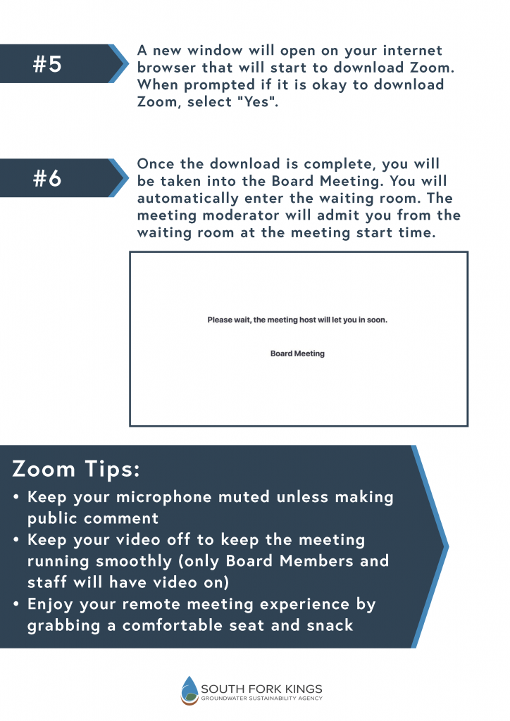
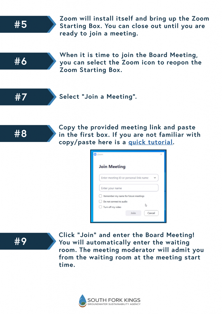
As a result of the COVID-19 emergency and the Governor’s Executive Orders N-29-20 and N-33-20, the upcoming South Fork Kings GSA Board Meeting will occur remotely via video and teleconference. There will not be a physical public access location. The South Fork Kings GSA will hold its upcoming meeting via Zoom, a video conference service for remote meetings (click here for virtual meeting protocol and logistics, including public comment). We know this is a departure from the norm. We have developed general guidelines for how to download and use Zoom to join our meetings. Keep in mind that depending on your device and method for joining the meeting the process may be different, but Zoom does a great job walking users through the process of joining a meeting.
For guidance on what Zoom method might work best for you, click below to follow our guides:
Lemoore, CA – The South Fork Kings Groundwater Sustainability Agency (SFKGSA) Board unanimously adopted the Tulare Lake Subbasin Groundwater Sustainability Plan at their January 16 meeting. The SFKGSA will use the Groundwater Sustainability Plan (GSP) as a roadmap to balance its groundwater. For the initial implementation period, the SFKGSA Board is operating under the assumption of an estimated groundwater overdraft of 38,000 acre feet per year. The GSP includes a full suite of supply enhancement and demand reduction programs the SFKGSA Board may consider to reduce this estimated overdraft number.
SFKGSA is the one of five groundwater sustainability agencies within the Tulare Lake Subbasin that have worked together to complete the Tulare Subbasin Groundwater Sustainability Plan. In addition to the SFKGSA, the Mid-Kings River GSA, El Rico GSA, and Tri-County Water Authority GSA have all unanimously adopted the GSP. The Southwest Kings GSA will consider adoption at a special board meeting on January 27. Upon completion of the adoption process, the GSP will be submitted to the State by the deadline of January 31.
Once the Tulare Lake Subbasin GSP is posted to the Department of Water Resources (DWR) web portal, it will be open to public comment for a minimum of 60 days. Public comments will be compiled and considered in DWR’s assessment of the GSP. DWR has two years from date of submission to evaluate and assess the Plan.
The SFKGSA will begin implementing their GSP immediately after submittal. The SFKGSA Board will begin developing policies and prioritizing the management actions and projects within the GSP to be implemented. In addition, the first annual report must be completed and submitted to DWR by April 2020.
The Board approved an assessment of $9.80 per acre for fiscal year 2020 at their June 20 meeting. Based on assessable acreage of 71,332.5, this generates a projected revenue of $699,059. This amount covers the 2020 budget of $666,246, which is the amount approved by South Fork Kings GSA landowners in the assessment election passed in 2018. Items included in the 2020 budget are administrative costs of $73,130, professional services in the amount of $377,650, and a $43,586 contingency fund. The $9.80 assessment also provides approximately $33,000 in additional revenue.
For Board consideration, Assistant Treasurer Brian Trevarrow presented Board members with two assessment options, $9.34 and $9.80. Trevarrow stated the proposed budget amount of $666,246 does not include money for legal expenses nor allow much cushion for cost increases. Another concern is the potential unplanned costs that may arise from implementing a new regulation as comprehensive and complex as SGMA (Sustainable Groundwater Management Act). Trevarrow also noted to date only $627,000 of the $698,000 revenue assessed last year is collected potentially leaving a $71,000 gap in uncollected revenue for fiscal year 2019.
Considering all of these factors, the Board decided it was prudent to approve the $9.80 rate for fiscal year 2020 to ensure the basic costs of implementing SGMA are funded and to lessen the impact of any possible shortfall in revenue due to unpaid assessments.