Skip to content Skip to footer

News

Tulare Lake Subbasin Not Compliant with SGMA According to State

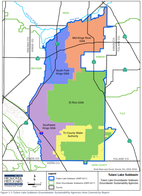
In early 2022, the Department of Water Resources completed its evaluation of the Tulare Lake Groundwater Sustainability Plan (GSP) and determined that it was Incomplete and that the five Groundwater Sustainability Agencies (GSAs) were required to address deficiencies identified by DWR. The deficiencies centered around the Sustainable Management Criteria for degraded water quality, land subsidence, and the chronic lowering of groundwater levels. In response to this determination, the Tulare Lake Subbasin GSAs submitted a revised Groundwater Sustainability Plan (GSP) to DWR in July of this year.

Four of the five GSAs including South Fork Kings, Mid-Kings River, El Rico, and Tri-County Water Authority adopted the same submitted revised GSP; however, the Southwest Kings GSA adopted a revised GSP with the following additional language:

 “Surface Storage of Groundwater – To the extent allowable by law, the GSAs will work with local and state regulatory agencies to prevent the inefficient storage of groundwater in shallow basins. This practice results in a significant loss of the pumped groundwater to evaporation. Avoiding these losses to evaporation would help in reducing groundwater pumping from the deep aquifer and lessen subsidence.”

Because the Southwest Kings GSA approval of the GSP is subject to additional language not found in the version adopted by the other four GSAs, DWR determined that the Southwest Kings GSA adopted a different GSP. As a result, the Tulare Lake Subbasin is no longer managed by multiple GSAs through a single GSP, but by multiple GSPs implemented by multiple GSAs. Consequently, a coordination agreement is required between the two GSPs.

The DWR reached out for a consultation with the State Water Resources Control Board as part of the intervention process for non-compliant GSPs. The State Water Board requested that DWR continue to review the revised GSPs for the Tulare Lake Subbasin to determine whether the technical deficiencies in the originally submitted GSP have been addressed. The State Water Board anticipates that it will wait to exercise its SGMA intervention authorities with respect to the Tulare Lake Subbasin until DWR completes its full technical review of the GSPs, which is currently scheduled for completion in early 2023. In the meantime, DWR asked that the South Fork Kings and the other GSAs in the Tulare Lake Subbasin continue with implementation of their GSPs.


Innovative Helicopter-Based Technology is Mapping Groundwater in the State, including over South Fork Kings GSA

South Fork Kings GSA landowners may see low-flying helicopter towing equipment over next several weeks

November 10, 2021

The California Department of Water Resources (DWR) is using an innovative, helicopter-based technology to gather information about the state’s groundwater aquifer structure to support drought response and implementation of the Sustainable Groundwater Management Act (SGMA).

Beginning November 19, 2021, DWR will conduct airborne electromagnetic (AEM) surveys of groundwater basins in the San Joaquin Valley in Kern, Tulare, and Kings counties, specifically in White Wolf, Kern County, Tulare Lake, Tule, and Kaweah. This includes areas over the South Fork Kings GSA. Landowners may see a low-flying helicopter towing a large hoop with scientific equipment approximately 100 feet above the ground surface. The helicopter crew may run test flights several days prior to the start of the surveys as well.

The helicopter, flown by experienced and licensed pilots, will make several passes over the survey areas.

“The data collected during these surveys will provide a better understanding of California’s groundwater systems, and in turn support more informed and sustainable groundwater management and drought preparedness and response approaches,” said Steven Springhorn, DWR’s SGMA Technical Assistance Manager.

Survey data creates an image of the subsurface down to a depth of about 1,000 feet below ground surface and provides information about large-scale aquifer structures and geology. This information supports the implementation of local groundwater sustainability plans (GSPs), which help local agencies like the South Fork Kings GSA sustainably manage groundwater during drought.

The AEM method is safe, and surveys have been conducted successfully in several locations throughout California. Surveys will be conducted during daylight hours only, and the helicopter will not fly over businesses, homes, other inhabitable structures, or confined animal feeding operations. The helicopter operator follows all established Federal Aviation Administration rules and regulations and their highest priority is public safety. Experienced pilots, who are specially trained for the low-level flying required for geophysical surveys, will operate the helicopter.

For more information about the AEM surveys, visit DWR’s AEM project website. For questions, please email AEM@water.ca.gov.

Conceptual diagram for how the AEM method works, CA DWR

For more information, watch DWR’s short 2-minute video on the AEM method, provided in both English and Spanish.

Survey conducted with local landowners sheds light on climate and drought perspectives

South Fork Kings GSA is conducting a series of surveys with landowners to better understand groundwater and land use. The first survey was designed to help the GSA understand landowners’ perspectives on how climate and drought impacts their groundwater supply.

Questions answered by respondents included: “On a scale of 0 (no threat) to 5 (greatly threatens), how much do you think climate change threatens your groundwater supply?” and “On a scale of 0 to 5, how would you rate the ability of your groundwater supply to recover from periods of drought?“.

The survey was conducted in June 2021, and results are now available to review on the survey webpage.

2022 Fiscal Year Updates

At the June 17th board meeting, the South Fork Kings Board approved the budget for the 2022 Fiscal Year. Here are a few items to note from that discussion.

Board levies $9/year assessment

The South Fork Kings GSA Board approved a resolution pursuant to South Fork Kings GSA’s 2018 Proposition 218 election, which authorized the Board to levy a five-year assessment up to the maximum of nine dollars and eighty cents per acre per year for SGMA implementation. The Board authorized an assessment of landowners for $9.00 per acre for fiscal year 2021-2022.

Board approves Geosyntec’s work orders for Fiscal Year 2022

Amer Hussain, a Geosyntec representative, presented task orders for the year as outlined by the Fiscal Year 2022 budget. Over the course of the year, Geosyntec will be performing the following task orders:

  1. Project Coordination/Meetings.
  2. Aquifer Storage and Recovery (ASR) Pilot Test- Geosyntec will finalize the ASR report to be submitted to the Regional Water Quality Control Board and Division of Drinking Water.
  3. ASR CEQA Document- A programmatic Environmental Impact Report under CEQA will be drafted and submitted to the Regional Water Quality Control Board.
  4. Groundwater Monitoring Program- This work will involve collecting semi-annual water level measurements, reviewing and evaluating GSA thresholds and objectives, and upholding commitments to monitoring programs as stated in the Tulare Lake Subbasin’s Groundwater Sustainability Plan (GSP).
  5. Database management.
  6. Grants- Geosyntec will research, manage and coordinate funding opportunities that South Fork Kings KGSA may qualify for and pursue.
  7. Project Design- Geosyntec will prepare and plan initial conceptual plans for project(s) and provide description of project(s) for the Tulare Lake Subbasin Annual Report.
  8. Surrounding Basin Coordination.
  9. Monitoring Well- The GSP identified five data gaps and outlined that five wells would be installed over time to gather that data. Geosyntec will coordinate the installation of a B-Zone well within a beneficial location to the GSA.

Separately, Geosyntec requested additional funds of $15,000 for the work they did to prepare the Water Year 2020 Annual Report on behalf of the Tulare Lake Subbasin. Additionally, Geosyntec also requested funding to prepare Water Year 2021’s Annual Report. Geosyntec anticipates that the Tulare Lake Subbasin will receive their comments from DWR on their GSP and then have 180 days to respond to these comments. Geosyntec is tasked with responding to these comments.

SFKGSA is only responsible for 15% of the fees charged to the Tulare Lake Subbasin for Annual Report work.

The Board approved these items.

Land IQ will provide important data to calculate groundwater extraction in the region

A one year contract with Land IQ was also approved by the South Fork Kings GSA Board. Land IQ will provide South Fork Kings GSA with evapotranspiration data, precipitation data, and land-use/crop data at a parcel level. This data will then be used to calculate groundwater extraction information.  Amer Hussain explained that in these calculations, surface water that is brought into the region will have to be subtracted. Land IQ will be directly contracted with South Fork Kings GSA to carry out this work.


Monitoring well will help to fill data gap identified in Groundwater Sustainability Plan

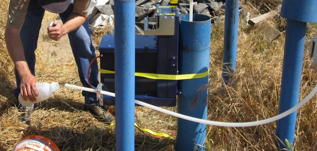
A monitoring well will be installed West of Stratford along Laurel Avenue using a sonic drilling method. The well will be 350 feet deep and 4 inches in diameter. This well will allow for water monitoring and sampling, providing missing data about water levels and quality that are necessary for effective implementation of the Groundwater Sustainability Plan.

Aquifer Storage and Recovery Pilot Test begins

South Fork Kings GSA is carrying out an Aquifer Storage and Recovery (ASR) pilot test, an innovative groundwater management method that involves injecting water for underground storage to be withdrawn later. Click here to learn more about the background behind the South Fork Kings GSA ASR Pilot Test.

The test began Monday, June 21st. South Fork Kings GSA is not using Lemoore Canal water, but the GSA is using their canals to carry out the test. The water for the test was purchased from a landowner. However, because the water will be returned, South Fork Kings GSA will only be paying for any water that is lost during the test.

The water will be injected for 30 days at approximately 800 gallons per minute and stored for 60 days. During this time, water levels in surrounding wells and the quality of the water injected will be monitored.

The water will then be extracted around September and returned to the landowner. The amount of surface water that is extracted and returned will be tracked. This will help the GSA to determine the efficiency of the test and how much water (if any) was not recovered.

In the future, this process could allow excess surface water to be stored in aquifers for future use in dry periods. Storing surface water and extracting it at the best time could play an important role in maximizing surface water supply in the region.

Sign up for our Interested Persons list to receive regular updates on this ASR Test and other activities going on in the GSA!

Survey mailed to landowners to determine drought impacts on groundwater

South Fork Kings GSA is conducting a series of surveys with landowners to better understand groundwater and land use in their area. The first survey in this survey is designed to help the GSA better understand landowners’ perspectives on how climate and drought impacts their groundwater supply.

The survey was in homes the second week of June. Landowners who submit their survey by June 30, 2021 will be entered to win one of fifteen $50 Amazon gift cards. The survey can also be taken online here.

Our goal as the South Fork Kings Groundwater Sustainability Agency (GSA) is to achieve a sustainable groundwater supply that is strong through cycles of drought. This survey series will help the South Fork Kings GSA better serve its landowners and stakeholders by helping us better understand their needs and the groundwater supply they rely on.

Airborne Electromagnetic Survey will help South Fork Kings GSA make groundwater management decisions

The Department of Water Resources has received funding from a Proposition 68 grant to conduct Airborne Electromagnetic (AEM) Surveys throughout the state.

During an AEM survey, a helicopter tows electronic equipment that sends signals into the ground which bounce back. The process has been compared to taking an MRI of the ground’s subsurface. The data collected is used to create continuous images that are interpreted for underground geology. The resulting information will provide a standardized, statewide dataset that improves the understanding of aquifer structures. It can also help with the development or refinement of hydrogeologic conceptual models and can help identify areas for recharging groundwater. (DWR)

These AEM Surveys will begin in Salinas valley, then move toward the southern Central Valley and work their way north. The data collected by the AEM survey will allow South Fork GSA to make informed groundwater management decisions, like what areas of the agency are ideal for recharging groundwater during wet years. After the flight has taken place, it will take about 6 months to get the AEM results from DWR.

The success of this survey is dependent on driller logs and the collection of other pieces of data. Stanford University and Dr. Rosemary Knight, are conducting additional subsidence modeling, digitizing well driller logs and well completion reports, and are looking to utilize NASA funds for this work. SFKGSA will write a letter of support for Dr. Rosemary Knight to show NASA that there is a need and interest in the collection of this data.

Groundwater in the Tulare Lake Subbasin: Annual Report Update

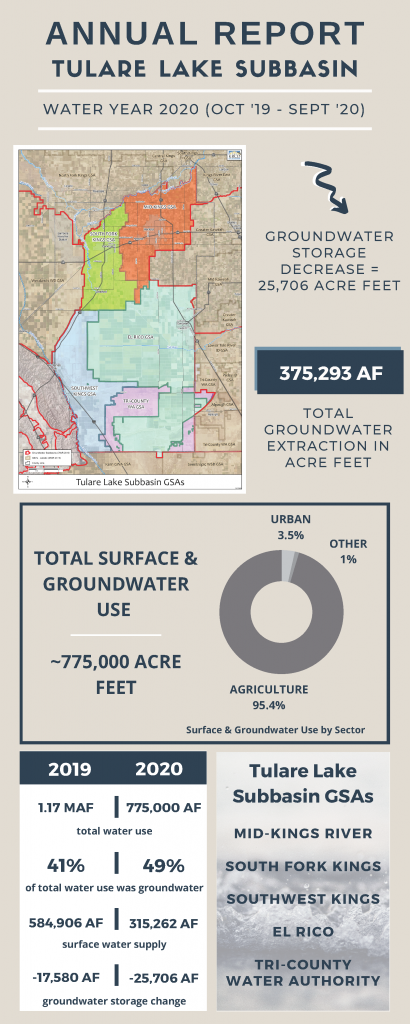
The South Fork Kings GSA (SFKGSA), together with the four other GSAs in the Tulare Lake Subbasin, submitted the second Annual Report to the CA Department of Water Resources (DWR) by the April 1, 2021 deadline.  Dryer conditions in water year 2020 (Sept 2019 – Oct 2020) strained groundwater supplies across the Tulare Lake Subbasin, evidence that cooperation among groundwater users and strategic surface supply management will be critical to achieving sustainability by 2040.

The Annual Report includes an overview of groundwater conditions in the region including groundwater extraction, surface water supply available for groundwater recharge, total water use, change in groundwater storage, and a description of progress made toward implementing the Groundwater Sustainability Plan (GSP) since the last Annual Report.

The Sustainable Groundwater Management Act (SGMA) requires Groundwater Sustainability Agencies (GSAs) to submit annual reports to the Department of Water Resources (DWR) on April 1 of every year.

The Tulare Lake Subbasin extracted 100,000 acre-feet (AF) less than the prior water year, but due to dryer conditions during Water Year 2020, the Subbasin also saw an overall decrease of 25,706 AF in groundwater storage as observed in this year’s Annual Report.  As we review the Annual Report and consider its implications as we enter another dry water year, SFKGSA will continue to implement innovative projects that will lead to a sustainable, resilient, and steadfast supply of groundwater for the region.

Here are a few SFKGSA highlights from the Tulare Lake Subbasin’s 2020 Annual Report:

SFKGSA participated in discussions with the San Joaquin Valley Blueprint to increase water supplies to the area.

Based on several wells being destroyed or inaccessible, SFKGSA worked with local landowners to modify the groundwater monitoring network. Access agreements were obtained for the modified network to ensure its long-term availability.

SFKGSA applied for and was awarded a grant from the California Resilience Challenge to implement an Aquifer Storage and Recovery (ASR) Pilot Test. Click HERE to learn more about this supply enhancement program and the progress made thus far.

SFKGSA participated in coordination meetings between the Kaweah and Tulare Lake Subbasins. The purpose of the meetings was to identify issues, discuss boundary conditions, and share data across the region. These meetings are expected to continue to help provide common solutions to regional issues. SFKGSA will continue to engage with neighboring subbasins and GSAs to promote inter-basin coordination.

Click HERE to read full Annual Report.

To receive updates on these projects and more, groundwater conditions, and other ways to get involved with the work SFKGSA is doing, sign up for our E-Updates and visit our website at southforkkings.org.
Translate »