Author: Website Admin
August 15, 2019 Board Meeting
The South Fork Kings GSA has scheduled a Board meeting on Thursday, August 15, 2019. The Board Meeting will begin at 5:30 pm. The meeting will take place at the Lemoore City Council Chambers, 429 C Street, Lemoore, CA 93245.
Board Approves $9.80 Assessment
The Board approved an assessment of $9.80 per acre for fiscal year 2020 at their June 20 meeting. Based on assessable acreage of 71,332.5, this generates a projected revenue of $699,059. This amount covers the 2020 budget of $666,246, which is the amount approved by South Fork Kings GSA landowners in the assessment election passed in 2018. Items included in the 2020 budget are administrative costs of $73,130, professional services in the amount of $377,650, and a $43,586 contingency fund. The $9.80 assessment also provides approximately $33,000 in additional revenue.
For Board consideration, Assistant Treasurer Brian Trevarrow presented Board members with two assessment options, $9.34 and $9.80. Trevarrow stated the proposed budget amount of $666,246 does not include money for legal expenses nor allow much cushion for cost increases. Another concern is the potential unplanned costs that may arise from implementing a new regulation as comprehensive and complex as SGMA (Sustainable Groundwater Management Act). Trevarrow also noted to date only $627,000 of the $698,000 revenue assessed last year is collected potentially leaving a $71,000 gap in uncollected revenue for fiscal year 2019.
Considering all of these factors, the Board decided it was prudent to approve the $9.80 rate for fiscal year 2020 to ensure the basic costs of implementing SGMA are funded and to lessen the impact of any possible shortfall in revenue due to unpaid assessments.
July 18, 2019 Special Board Meeting – cancelled
The South Fork Kings GSA special Board meeting on Thursday, July 18, 2019 has been cancelled.
Twelve Wells will Monitor Groundwater
South Fork Kings GSA’s technical consultant, Geosyntec presented at the May 23 Board workshop the proposed well network to be included in the Groundwater Sustainability Plan. Three locations within the SFKGSA service area have been identified. The wells at these locations are where the GSA will measure water levels to report to the State Department of Water Resources.
The wells will provide data from three separate levels in the aquifer from shallow to deep: zones A, B, and C. A-zone wells are located in the shallow perched area of the aquifer within the top 100 feet above the A Clay. The B-zone wells are below the A Clay layer and above the Corcoran Clay, the deepest clay layer. It is an unsaturated aquifer so water levels go up and down. The C-zone are wells installed below the Corcoran Clay. It is a confined aquifer so there is less variation of what is occurring in the aquifer at that level.
The network will use existing wells but will also require the drilling of additional wells to ensure adequate data is collected. Currently, there are seven existing wells in the three locations that are part of the Kings River Conservation District’s monitoring network. There is one well in the A-zone and six wells in the B-zone. Five additional wells will need to be installed to complete the network, two in the A-zone and three wells in the C-zone.
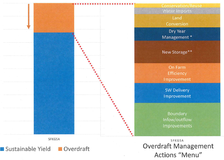
Creativity and adaptive management will reduce 45,000 AF of estimated overdraft in the South Fork Kings
The South Fork Kings is tasked with stabilizing groundwater levels to reach sustainability under SGMA. This means reducing the near 45,000 acre-feet per year of groundwater overdraft in the GSA, an estimation calculated by the subbasin’s groundwater model. A menu of projects and management actions to reduce the groundwater overdraft was presented by the GSA’s technical consultant at the April 18th Board workshop.
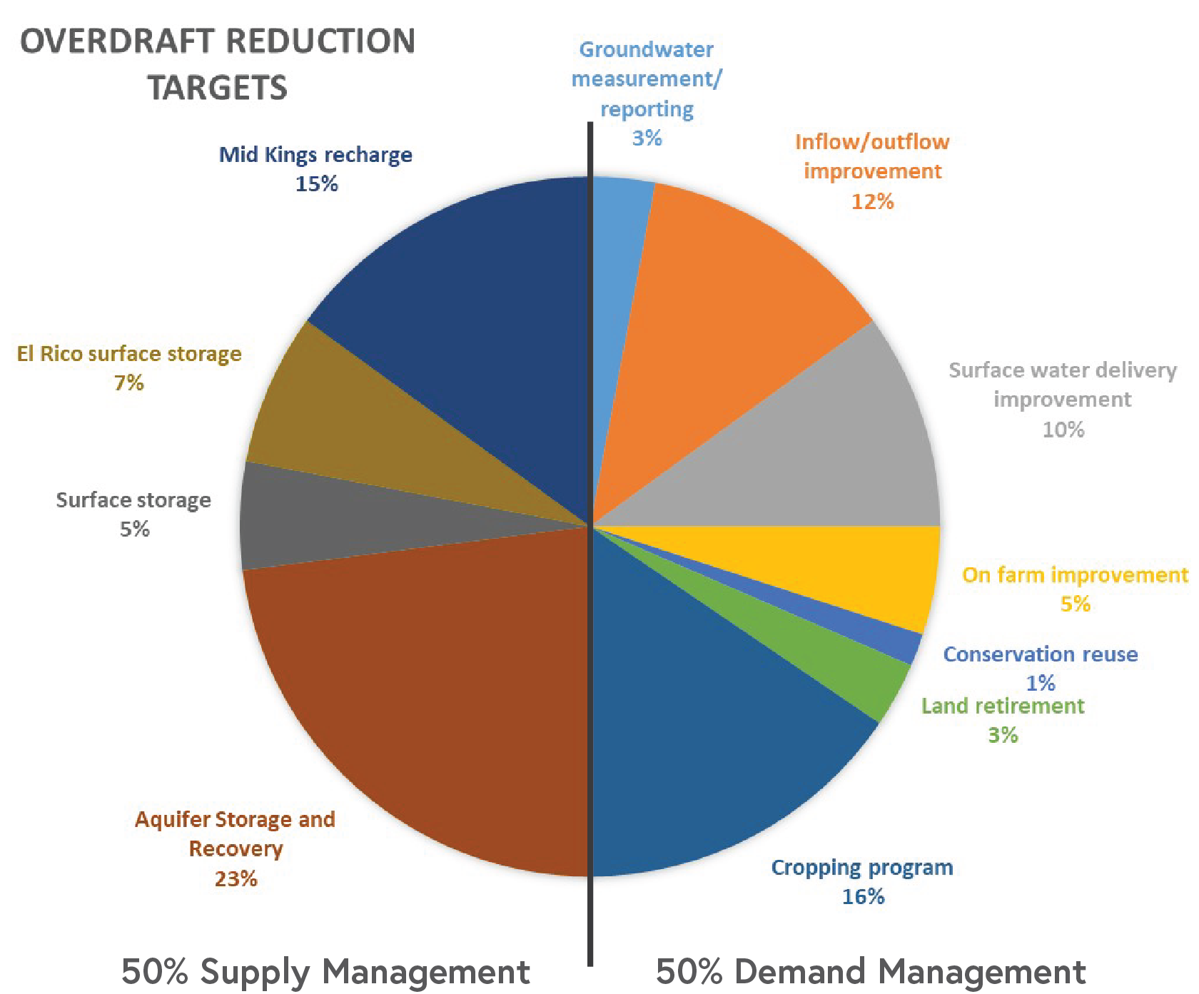
A combination of supply-side and demand-side solutions will achieve sustainability. Solutions will either increase available water supply to offset groundwater pumping and/or will decrease the demand for groundwater. The technical consultants outlined specific projects and actions for consideration during these next few years of sustainability planning.
The percentages represent the proportion of overdraft each item will solve. Please note these proportions and management actions are in preliminary draft form.
On the demand side, on farm improvements in irrigation efficiency and water treatment could save an estimated 2,230 acre-feet per year. Land retirement with opt-in incentives and land repurposing, such as solar farms, could yield a savings of 1,340 acre-feet per year.
There is potential to cooperate on supply-side projects that benefit the entire subbasin. One example is cost-sharing for constructing recharge basins on especially suitable soils in surrounding GSAs. Although primarily used by municipalities, Aquifer Storage and Recovery (ASR), a process in which water is injected into the aquifer for storage and subsequent withdrawal, is being studied for agricultural application. ASR has the potential to reduce overdraft by an estimated 10,258 acre-feet per year.
As the South Fork Kings GSA progresses with its Groundwater Sustainability Plan (GSP), balancing SGMA compliance with economic impacts to the service area is a high priority for the Board. Developing creative solutions and adaptive management actions will ultimately drive sustainability success and secure the region’s water supply for years to come.
Preliminary Monitoring Network Identified
SFKGSA’s technical consultant, Geosyntec, has researched and identified wells for consideration as part of the Groundwater Sustainability Plan monitoring network. The wells will provide data from three separate levels in the aquifer, zones A, B, and C. A zone wells are located in a perched area of the aquifer within the top 100 feet above the A Clay. The B zone wells are below the A Clay layer and above the Corcoran Clay. It is an unsaturated aquifer so water levels go up and down. The C zone are wells installed below the Corcoran Clay. It is a confined aquifer so there is less variation of what is occurring in the aquifer at that level.
Additional wells will be considered for the monitoring network, and new wells may need to be installed to ensure there are no data gaps in the network. In addition, data sharing is anticipated with neighboring GSA wells along the outer boundaries of the South Fork Kings GSA area.
Monitoring Network Preliminary Wells Map